|
|
|
 |
|
|
|
|
The Waterfalls of Sri Lanka are breathtaking and a spectacular
sight to watch. These waterfalls are rich in beauty, considering it's
gigantic curtain of water that begins at the very point of descent at
the (mountain which the fall originates) streaming graciously in a downward
motion while hitting smaller rock's in it's path there by causing a splash
resulting in the birth of a pond created by the accumulated water particles
of the splash and finally resulting in the distribution of water to a
nearby river by means of a downward motion of water streams. Waterfalls
have been a magnificent gift of nature, which has attached human beings
since the beginning of time. Some of the famous & picturesque waterfalls that could be seen in Sri Lanka are as follows
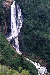
Ramboda falls
Rambodde Falls comprise several waterfalls fed by small brooks that flow into the Panna Oya, a tributary of the Kotmale Oya. These falls are situated on the A5 road as it makes its tortuous way through the steep Rambodde Pass. James Emerson Tennent writes of the road and the falls in Ceylon (1859): The road from Pussellawa winds through the valley skirting the bases of the hills, till it reaches an apparently insurmountable barrier of mountains in the glen of Rambodde. Here the acclivities that bound the ravine are overcome by a series of terraced windings, cut out of the almost precipitous hill; and so narrow is the gorge that the road enters between two cataracts that descend on either side of the pass. Tennent refers to the biggest of the Rambodde Falls, the 109-metre high twin-fall, which flows over the rock ledge north of the A5. This, incidentally, is the 10th highest fall in Sri Lanka. There is a smaller fall of 30 metres that crosses the A5 at Rambodde village. Tennent goes on to describe some of the remarkable insects to be found by these falls: In the damp shade near these waterfalls the delicate spectre butterfly is seen in unusual
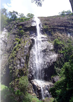
Ravana Ella( Ravana Falls) It is on the Ella –Wellawaya road and visible from the
main road. Although the main drop is 30 ft in height, it’s a wide
fall and the water rushes over several steps adding to it’s beauty.
Diyaluma ,on the Poonagala Oya rever off the Koslanda- Wellawaya
road is another spectacular sight spilling over a straight rock wall.
559 ft in height. Diyaluma is often rated as Sri Lanka’s highest
water falls, upstaging Bambarakanda.It is 13 km from Wellawaya town and
6 km from Koslanda in the Hills and seen like a soft veil, is seen from
the Balangoda – Wellawaya highway too. The Sinhala name Diya Luma - more correctly Diya Haluma - means water-gush. On the other hand Diya Luma may be translated as liquid light. This alternative meaning is connected with an ancient story retold in more recent times by R. L. Brohier: In unsettled times, when the island was disintegrated into many principalities, there was a young chieftain who was for some reason banished from his clan and forced to live in exile in the highlands of the natural rampart which rose from the maritime plain. He was betrothed to a lady of high degree who, rather than forsake her lover, was determined to join him. All the passes leading from the low-country to the hills were
strongly guarded. Consequently escape was impossible. One day, as she
stood gazing at the precipitous mountainside, an idea began to take shape
in her mind. Here indeed was an obscure way of leaving her home, an altogether
bold and daring plan. She bribed an emissary to carry a letter to her
lover disclosing how she proposed to join him, minutely
Makes a leap of 100 ft on the Kurd gang, a tributary of the Kale ganga.a water fall not known for it’s height but for the sheer beauty of formation. The name Bo path Ella derives from it’s perfectly heart shaped head, much like the leaf of the sacred bo tree. It is one of the favorites picnic spot of Sri Lankans due to it’s proximity to the city of Colombo. just 15 km from Colombo-Ratnapura road, once reached the Higashena junction, and then branches off to the Agalawatta road and from there it’s only a few minutes…Bopath Ella Falls, which are 30 metres high, are situated on the Kuru Ganga, a tributary of the much larger and better known Kalu Ganga. The name Bopath is derived from Bo - the ficus religiosa, the sacred tree under which the Buddha attained enlightenment - and from Pata - which means leaf. This is because the falls have three cascades that give the appearance of the rounded shape of the leaf of the Bo tree. Several hundred metres beyond the falls the Kuru Ganga is joined by another stream. Between the falls and the confluence of the two streams is a sandy area with several pools of turbulent cold water, ideal for picnicking. Although the Bopath Ella Falls are one of the nearest to Colombo, they cannot, like many others farther away, be seen from a highway or vantage point. To reach them, travel via Avissawella on the A4 to Dehipala. There turn left and proceed to Agalawatte. Keep to the right at the junction in the town, and the small road will take you through a rubber plantation. When you drive out of the plantation you will Devon Falls
H. W. Cave eloquently describes the falls as they appear on this road in The Ceylon Government Railway (1910): Two miles farther on the same winding road, one of the most beautiful landscapes in Ceylon is to be found, where, at an abrupt corner of the road, the Devon Falls bursts upon the sight. No photograph can do it justice; the charm of the view is in the setting of the waterfall with its steep and rugged background of rock, and the estates at various elevations towering above it, while the more distant ridges one by one recede till the farthermost is lost in rolling vapours.
|
 If
you ever tasted a cup of good High Grown Ceylon Tea, preferably in the
unblended form, you have tasted the BEST TEA there is. Of course, to experience
that pleasure, you must go to the central hill country of Sri Lanka. And
once you are there, take Route 5 from Maha Nuwara (Kandy) to Nuwara Eliya.
This take you through some of the best scenery of the Hill Country. The
road takes you by the shores of Mahaweli River from Peradeniya ( don't
forget to visit the famous botanical gardens - remember "Bridge on
the River Kwai?") to Gampola, long ago a capital of Sri Lanka. From
Gampola it is a steep climb with many hairpin curves for some sixty kilometers,
through spectacular scenery like this, until you get to Nuwara Eliya,
the old British hill resort. To taste that heavenly cup of tea, on the
way to Nuwara Eliya, look out for tea factories that advertise tea tasting.
You won't forget that unique experience.
If
you ever tasted a cup of good High Grown Ceylon Tea, preferably in the
unblended form, you have tasted the BEST TEA there is. Of course, to experience
that pleasure, you must go to the central hill country of Sri Lanka. And
once you are there, take Route 5 from Maha Nuwara (Kandy) to Nuwara Eliya.
This take you through some of the best scenery of the Hill Country. The
road takes you by the shores of Mahaweli River from Peradeniya ( don't
forget to visit the famous botanical gardens - remember "Bridge on
the River Kwai?") to Gampola, long ago a capital of Sri Lanka. From
Gampola it is a steep climb with many hairpin curves for some sixty kilometers,
through spectacular scenery like this, until you get to Nuwara Eliya,
the old British hill resort. To taste that heavenly cup of tea, on the
way to Nuwara Eliya, look out for tea factories that advertise tea tasting.
You won't forget that unique experience. 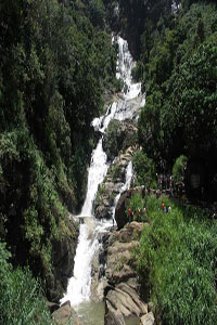
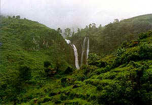
 Diyaluma Falls( skein of water)
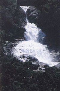 Bopath
Ella (Bo-leaf fall)
Bopath
Ella (Bo-leaf fall)